We are pleased to introduce an article about the canyon Perin Potok in this year’s issue of “Montenegro” magazine (Chernogoria). This is a luxurious seasonal magazine dedicated to Russian tourists in Montenegro and Russian citizens who have chosen Montenegro for their second home. It has the best quality with the largest number of readers in Russian. The first issue was released in spring, 2007.
Perin potok
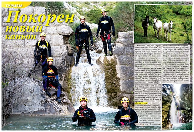
“Extreme Canyoning” team, whose goal is to create a guide through the canyons of Serbia and Montenegro, recently visited the new canyon of Montenegro – Perin potok, in the seaside area covered with olive trees.
Suva rijeka or also called Perin potok, is located on the sacred mountain Rumija, between Skadar Lake in the northeast and the Adriatic Sea or the Bar field, in the southwest. It flows into the small river Rikavac which is flows into the sea a little bit further. The canyon is oriented towards the southwest.
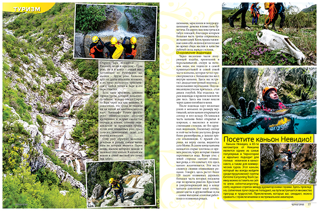
In parallel to the canyon Suva rijeka, there are canyons Rikavac and Vruca rijeka. If you make them location-lined from left to right, looking from Bar, and also the graduation in size and impression, right next to the Old Bar is Rikavac, then in the middle is Suva rijeka and ultimately the greatest impression of Rumija canyons – Vruca rijeka. Each of these canyons are separated by a hill, which makes them easily recognizable from most of the cities of Bar and the surroundings.
There is a very beautiful, old mountain and shepherd’s path that moves from Old Bar and intersects all three canyons. Unfortunately, this trail is not marked on any map, though there are many of them. The terrain of Rumija is characterized by low thorny bushes and sharp rocks, hence moving out of the paths, meadows and olive trees is almost impossible, even for many animals.
Suva rijeka originates from several creeks and streams, and the most important is Perin potok by which name many people call this canyon. We entered the canyon on the highest part, under the abandoned, overgrown remainings of Lumetic’s houses and estates. Along the way we came across a herd of horses thanks to which there is still a path on which we were walking. They are on their own and are only being used during the olive harvest in the labor force along with donkeys.
Majesty of the waterfall
After several hours of exhausting walking, threading and jumping, following the watercourse, we arrived at the most attractive and the narrowest part of the canyon, which is clearly visible from most places within it. There is a waterfall of about twenty meters, where the water is spilled in several places. Below the flow there was a flock of wild pigeons. We gave ourselves to the charms of the waterfall and stayed for almost two hours. Here we also found the skull of long-dead horse.
After this section there are several narrow and smaller pits, after which the canyon opens to the sun and the southwest. The rest of the canyon is more open and wider with high and imposing walls, but without bigger waterfalls. Since the sun is more accessible in this part the flowers are more diverse and the scents are almost intoxicating. On the right side on top of a cliff the village Menke van be seen. Towards the end of the canyon there are old dams from Roman times through which the water is poured out properly. Shortly thereafter the cliff on the left is replaced by olive trees, which is also a sign that we have reached the end of the canyon. The whole area is known for its olive trees and it is believed that there are over 120.000 trees which are mainly planted during Roman times. A beautiful and relaxing scene at the end of the canyon is complemented by sunset, wild flowers and sociable donkeys as the most profitable seasonal workers in the olive groves.
Text: Miloš Radević / extremecanyoning.com
Photo: Predrag Vučković / extremecanyoning.com